Always refer to the main Pearson general guidelines and science guidance when writing alternative text for images.
When describing Geography and Geology images, keep in mind the following key aspects and examples. Not all guidance will apply to all images.
- Describe meaningful features:
- Location: the position of a geographic or geolocial feature
- Space: distance between geographic or geological features
- Place: unique characteristics of a location or feature
- Pattern: meaningful arrangement of geographic or geological features, based on location, space, and place (or type)
- Regionalization:organization ofdistinct areas
- Globalization: economic, political, and cultural activities or trends
- Use precise and descriptive language to convey the characteristics of the geological formations or the geographical features, such as “limestone layers,” “igneous rock formations,” “a steep canyon,” “a meandering river,” “a flat plain,” or “a rugged coastline.”
Reminder: The Mastering authoring platform has a title field and alt text field but does not have the functionality for a long description. Alternative text descriptions in Mastering may have more than 255 characters. The eText 2 authoring platform has the functionality for alt text and a long description. For more information about the different authoring systems, see Platform Authoring Information.
Examples
Example 1

Alt Text
Maps demonstrate a spatial trend in West African Ebola cases in 2014. In March, the disease was concentrated in a few districts in Liberia and Guinea. By November, it had spread to almost all districts in Liberia and Sierra Leone and half of Guinea.
Example 2

Alt Text
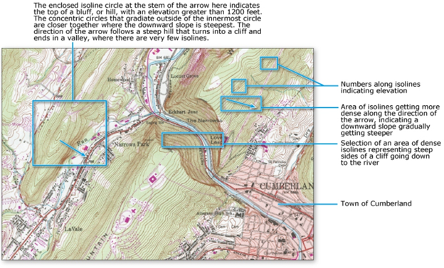
A contour map of the area around the town of Cumberland.
Long Description
(Must be marked up in HTML)
The contour map shows different elevations as curves called isoclines. The isoclines represent topographic features as follows:
- Numbers along the isoclines indicate the corresponding elevations.
- In one area, isoclines get denser in the direction of increasing elevation. This indicates a slope that is gradually getting steeper.
- Dense isoclines on either side of a river represent steep cliffs rising above the river banks.
- An enclosed, circular iscoline indicates the top of a bluff, or hill, with an elevation greater than 1200 feet. The concentric circles that gradiate outside of the innermost circle are closer together where the downward slope is steepest. These iscolines get denser in the direction of decreasing elevation, eventually representing a cliff. The isoclines then spread out to show a valley.
Example 3

Alt Text
A line graph shows global annual mean temperature.
Long Description
(Must be marked up in HTML)
The graph plots temperature in degrees Celsius versus year for the period from 1880 to 2013. The graph rises and falls over intervals of 1 to 4 years, but it has a general upward trend. The graph starts (1880, 13.4), passes through (1960, 14), and ends at (2013, 14.8). The steepness of the graph increases after 1964. All values estimated.
Example 4

Alt Text
A labeled photo shows the different parts of an alluvial fan.
Long Description
(Must be marked up in HTML)
The photo shows the frontal view of an alluvial fan at the base of a slope in Death Valley, California. The cross-fan profile is concave down. The highest point on the profile is the apex of the fan. Relative to water runoff at the fan’s base, the inactive portion of the fan is upstream of the apex. The active portion is downstream of the apex.
Example 5

Alt Text
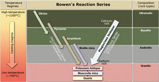
A diagram shows how Bowen’s reaction series relates to temperature regimes and rock composition.
Long Description
(Must be marked up in HTML)
During Bowen’s reaction series, magma temperature decreases from around 1200 degrees Celsius to around 750 degrees Celsius. This decreasing temperature causes the rock to transition between the following composition types: ultramafic, basaltic, andesitic, and granitic. During this process, minerals solidify via a discontinuous or continuous series of cystallization.
In discontinuous crystallization, the following minerals solidify as temperature decreases.
- Olivine in higher-temperature ultramafic rock
- Pyroxine in lower-temperature ultramafic rock
- Amphibole in basaltic rock
- Biotite mica in basaltic rock, just before the transition to andesitic
In continuous crystallization, calcium-rich plagioclase feldspar starts to solidify in ultramafic rock. As the temperature drops, the solidifying plagioclase becomes increasingly sodium rich.
Regardless of whether crystallization is discontinuous or continuous, potassium feldspar solidifies in higher-temperature granitic rock. Then, as the rock cools further, muscovite mica and quartz emerge.
Example 7

Alt Text
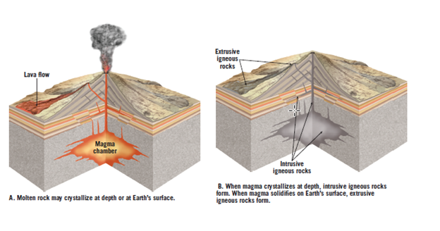
2 diagrams illustrate the difference between intrusive and extrusive igneous rocks.
Long Description
(Must be marked up in HTML)
Diagrams A and B show a volcano in different stages of eruption. In diagram A, liquid magma in the magma chamber rises to the surface and forms a lava flow. In diagram B, the magma cools to form igneous rock. The igneous rock above the surface is extrusive. The igneous rock below the surface is intrusive.
Dated: 2023-12-01
